Saturday, November 12, 2011

Halloween Storm

Well, Halloween Eve, really. 17 inches of wet snow with leaves still on the trees brought down many branches. Power out for seven days.


Canal

Reflections in the canal between Moffett Field and the San Francisco Bay in Sunnyvale, California.

Field

Field at Half Moon Bay, California.

Thursday, October 13, 2011

KOA Kampground, Madras, Oregon

This part of Oregon is a combination of rolling farmland (irrigated) and dry ranchland with the snow-covered giants Mount Hood and Mount Adams looming in the distance.

Our campground near Madras, Oregon.

When we were kids, the KOA campgrounds always had the best showers. That still seems to be true today.


On The Road to Oregon

We've begun our road trip to New York. For the official perspective, see GWS Takes Manhattan.

Our vehicles in pristine condition in San Leandro, California. 
The Pac Man car, sighted north of Sacramento.

Carquinez Bridge

Heading north on Interstate 5.

Sunday, September 25, 2011

California Central Coast Déjà Vu

I drove down California 1 today from Half Moon Bay to Santa Cruz, and I realized I'd been on this road about 25 years ago, after dropping Claire off at SFO airport for a rafting trip in Idaho.  I stopped off for the night back then at the Pigeon Point Hostel before continuing on down the coast to do some hiking in the Ventana Wilderness.
Parking lot, Half Moon Bay, California

Pigeon Point, California
Pigeon Point Hostel. Ed Bacher slept here.
Pacific Ocean from Pigeon Point


Friday, September 23, 2011

More Commuting

I took these photographs this morning with my phone and uploaded them to Google+.  So now they're magically in my Picasa album and I can easily post them here.  Haven't quite figured out yet whether I need to cross-post stuff, but this blog is more linear than the G+ stream. (As always, you can click on the picture for a larger version.)

Phone cameras have certainly come a long way.  Compare to the SavaJe phone pictures from a few years ago in this post: http://beanroad.blogspot.com/2007/06/mobile-phone-pictures.html.

Looking toward the mountains in the East Bay from the San Francisco Bay Trail.

My commuting vehicle. I bought this around when Annie was born, so it's about 20 years old and still going strong.

Sunrise over Poverty Ridge (I think).

Saturday, August 20, 2011

Nice commute in California

For now, I'm living in Sunnyvale, and can ride my bike to work along the San Francisco Bay Trail. Won't last forever, so I'm trying to appreciate it now.
San Francisco Bay Trail

Moffett Field from the San Francisco Bay Trail

Thursday, May 5, 2011

Railroad/Road Bridge in Maine

I just came across this apparently unique bridge in the HABS/HAER archives.  The Free-Black bridge spans the Androscoggin River between Brunswick and Topsham, Maine.  It carries a branch of the Maine Central on top, and a single lane road bridge suspended below.

Free-Black Bridge, Brunswick-Topsham, Maine.
Photo by Jet Lowe for HABS/HAER.

The following picture gives you a better idea of how the roadway is suspended from the steel truss railway bridge.

Free-Black Bridge Road Deck, Brunswick-Topsham, Maine.
Photo by Jet Lowe for HABS/HAER.

This bridge was built in 1909, and I was afraid it might have been demolished since Jet Lowe took these pictures in 1994, but a check of Bing Maps shows that it is still there.


Free-Black Bridge, Brunswick-Topsham, Maine.
From Bing Maps
According to an article in The Forecaster,
After a driver struck a support beam on the one-lane bridge in early April, the DOT closed the bridge and engineers discovered the pressure-treated wooden guard rails were rotting.
The bridge is now closed to traffic, but it's still there, so I'll have to go see it.

Thursday, February 24, 2011

Kennebec Bridges, Waterville, Maine

There are a couple of nice bridges in Waterville.  The Ticonic bridge is a pedestrian bridge about 200 yards above the Ticonic Falls:

Ticonic Bridge, Waterville, Maine.

At the falls themselves is a massive railroad bridge:

Railroad bridge, Kennebec River, Waterville, Maine.

Another view of the railroad bridge:

Barrel view of Ticonic Falls railroad bridge, Waterville, Maine.

Lap Order, August 1932

August 3, 1932, Rutland, Massachusetts.

(Click the picture to see the large version.)
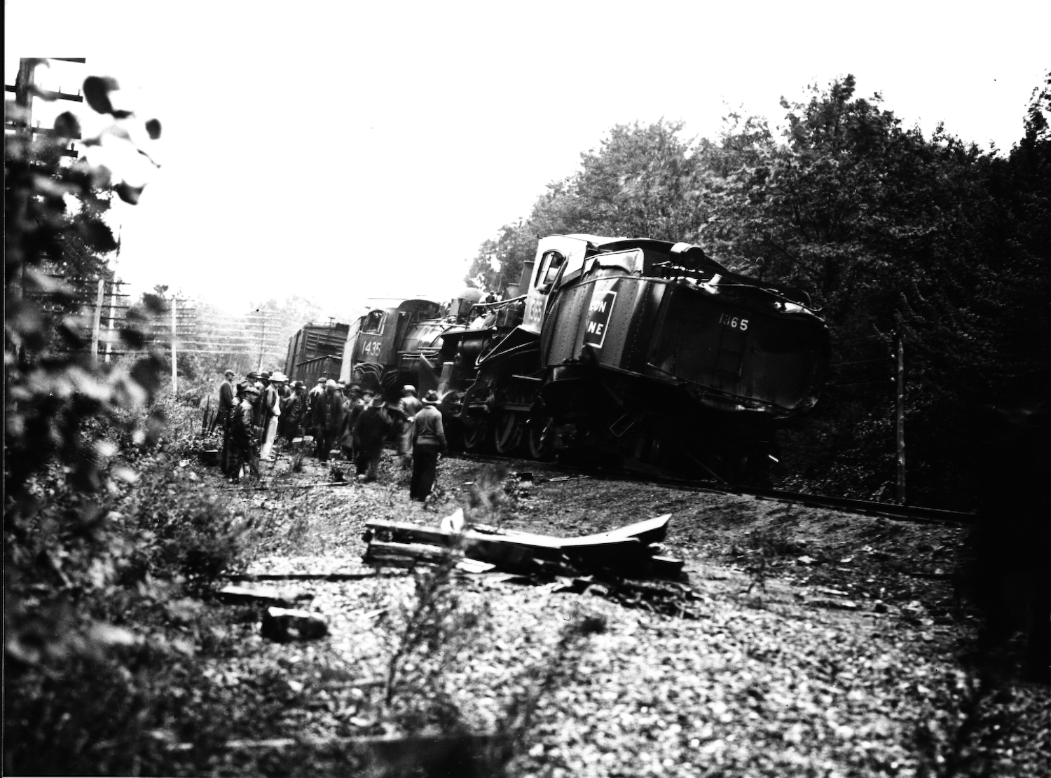
This photograph, taken by Harold Judkins of Rutland, Massachusetts, shows the wreck of Boston & Maine locomotives 1435 and 1365. My grandfather was the fireman on engine 1435, and both he and the engineer died in the wreck. The engineer and fireman of locomotive 1365 apparently jumped and survived. The immediate cause of the wreck was a lap order issued by the dispatcher that allowed both trains access to the same stretch of track, but the exact circumstances remain a mystery.

The ICC accident report appears below:


Thursday, February 17, 2011

Jet Lowe in Cleveland


In the summer of 1979, Jet Lowe took a series of photographs of these huge machines used to unload ore from ships on Lake Erie. In this photograph, you can see a ship  (the George M. Carl) docked to the left of the massive Hulett ore unloaders.  Downtown Cleveland is in the distance.

Pennsylvania Railway Ore Dock, Lake Erie at
Whiskey Island,
approximately 1.5 miles west of
Public Square, Cleveland, Cuyahoga, OH
The unloader operator could drop the ore directly into waiting rail cars for immediate shipping, or deposit it in the storage yard to the left.

Sunday, January 16, 2011

Horseshoe Curve, Altoona, Pennsylvania


Altoona, Pennsylvania, October 12, 1934

 
(Click the image for a larger version.)
This photograph is from the panoramic photograph collection of the American Memory project at the Library of Congress. The horseshoe curve carried the Pennsylvania Railroad at a reasonable grade through the Allegheny Mountains. Designed by John Edgar Thomson (who soon become president of the PRR) and Herman Haupt (who later started digging the Hoosac Tunnel in western Massachusetts and was a Union general in the Civil War) designed the  curve. The horseshoe curve opened on Feburary 15, 1854.

Here's the satellite image from above (via Google Maps). Click the image to view the map itself.