Sunday, August 7, 2016

View from the marine terrace, Santa Cruz

The shoreline near Santa Cruz is pretty cool. This article about marine terraces on the Mobile Ranger blog explains it.

Santa Cruz, California


Santa Cruz, California

View from the second marine terrace on Back Ranch Road.

Thursday, August 4, 2016

Public art: Mission Street, Santa Cruz

Santa Cruz Mission, Santa Cruz, California
There's lots of formal and informal public art around Santa Cruz. Last spring, a large group of volunteers installed this large mosaic mural at the entrance to the Santa Cruz Mission. Two students at the middle school designed the mural.

Santa Cruz, California
This is the plaque with the artists and supporters.


UCSC Tanks, Santa Cruz, California
There's some art in the woods above UC Santa Cruz.


Wednesday, August 3, 2016

Rail rider, Santa Cruz

Wilder Ranch, Santa Cruz, California

I was riding home after a longer-than-expected exploration of the Smith Grade area in Santa Cruz, when I spied this guy putt-putting up the coastal rail line. You can barely see him among the brussels sprouts (Click on the photograph for a larger view).

While he used a powered cart, he reminded me of this hilarious account of a similar wind-powered adventure in Montana, recounted by the inimitable Bill Vaughn.


Tuesday, May 24, 2016

Public art, Amarillo, Texas


On our way back from North Carolina to Santa Cruz via I-40 and Route 66 and taking in some of the sights.

Cadillac Ranch. Amarillo, Texas
Cadillac Ranch artist

Amarillo, Texas

Sunday, March 6, 2016

Arroyo Seco

Arroyo Seco Canyon, Santa Cruz, California
Arroyo Seco no está tan seco hoy.

We had over two inches of rain yesterday from an El Niño storm. This canyon and the creek are normally bone dry, but everything is pretty green now, and yesterday was literally over the top.

Sunday, February 21, 2016

Monterey Bay

After moving to California from the East coast, it took me a while to get used to the fact that driving toward the ocean is generally west, not east. Even more confusing is that Santa Cruz faces due south, so the ocean is not to the west here, unless you head north or south of town.

In any case, some days the views in any direction are sublime. We've gotten some rain this winter, so the fields are looking pretty lush again. This is the view looking south toward Monterey from the Coastal View trail in Moore Creek preserve just west of Santa Cruz.

Monterey Bay from the Moore Creek Preserve, Santa Cruz, California

Friday, January 22, 2016

In Patagonia

Many years ago, my roommates made me a gift of Bruce Chatwin's book In Patagonia. The book itself is fantastic. Worth reading and rereading. And it made me want to go to Patagonia someday.

Last year, our kids, who were working and studying in Buenos Aires, invited me to come join them for a week of hiking and exploring in Patagonia. I jumped at the chance, and I was not disappointed with either Patagonia or with Buenos Aires.

Panoramic view of El Chaltén, Patagonia. Image from Wikipedia: https://en.wikipedia.org/wiki/El_Chalt%C3%A9n#/media/File:El_Chalt%C3%A9n,_panoramic_view.jpg
El Chaltén, Patagonia
My only regret is that we did not have clear enough weather to see the peaks looming right behind the village of El Chaltén. The panoramic view above shows what we missed (click on it for the full-sized image). We'll just have to go back.

Tuesday, January 19, 2016

El Niño comes to Santa Cruz

This past weekend,  El Niño brought more rain and big surf to Santa Cruz. This spot, just around the corner from the surf spot at Steamer Lane, is popular with some swimmers who dive off the rocks into this small cove. No diving today.

The toilet bowl at Lighthouse Point, Santa Cruz.
(As always, you can click the picture for a larger image.)
Update: a friend pointed out that Winslow Homer painted a scene in Maine that resembles this one. The interesting thing is that Homer painted a stop-action image before most cameras (and films) could support the low shutter speeds (less than 1/30 of a second) needed to stop action like this. He had vision.

Winslow Homer, West Point, Prout's Neck,1900.
The Clark Art Institute, Williamstown, Massachusetts.

Tuesday, November 24, 2015

Ruby's

Ruby's Taqueria, Sunnyvale, California
Try the vampiros: they will make you happy.

Monday, November 2, 2015

Pumpkin time

Finally, a practical use for pumpkin guts:

Pumpkin carving contest. Elon, North Carolina

Sunday, November 1, 2015

Companion, Wilder Ranch Bike/Run

I biked down the canyon to Companion Bake Shop this morning for a maple-bacon biscuit and a latté. Then I headed up the Route 1 bike trail to Wilder ranch and up the Englesman Loop Trail. There's some nice single-track trail that heads off toward Wilder Creek and Cave Gulch and back to UC Santa Cruz. Great way to start off November.

Trail in Cave Gulch. Wilder Ranch, Santa Cruz.

Saturday, October 3, 2015

Ashland, Oregon

For the first time since we were kids, I'm able to drive to visit my sister, now that she lives on the same coast (and the same continent). Ashland is only about a 7-hour drive from Santa Cruz, and I finally made the trip this weekend. After spending most of the day in the car, I unwound with a run on the trails just south of town.

View north from the White Rabbit Trail, Oredson-Todd Woods, Ashland, Oregon.

Today we drove into the hills north of town and explored a bit.
In the hills north of Ashland, Oregon.
There is a wonderful dirt road that meanders around the Ashland watershed. I explored a bit this afternoon in the car, but next time I'll bring my mountain bike.
Ashland Loop Road south of Ashland, Oregon in the Siskiyou Mountains.


Saturday, March 21, 2015

Barn Raising in Santa Cruz

Santa Cruz, California
The new Cowell Ranch hay barn at UC Santa Cruz replaces the 150-year old original with a traditionally-built timber frame barn in the same location. The barn will house the Farm and Garden program at UCSC.

Buses

Buenos Aires, Argentina

Buenos Aires, Argentina
Buenos Aires runs on its buses, and each line has its own color scheme, so you can see from a distance if your bus is coming.

Wednesday, March 18, 2015

Go, pi

I have a friend who used to know \(\pi\) to about 50 places. I can barely remember nine. But on pi day last weekend, I wrote a little Go program that approximates \(\pi\) by calculating many terms of an infinite series (Nilakantha's Series).

You can express Nilakantha's series as: $$\pi = 3 + \frac{4}{2\times3\times4} - \frac{4}{4\times5\times6} + \frac{4}{6\times7\times8} - \frac{4}{8\times9\times10} + \dots$$

Here's the Go program:

  package main

  import (
          "fmt"
          "os"
          "strconv"
  )

  const ndefault = 10000

  func main() {
          // How many iterations?
          n := ndefault
          if (len(os.Args) > 1) {
                  n,_ = strconv.Atoi(os.Args[1])
          }
          if n == 0 { n = ndefault }
          fmt.Println("n =", n)

          pi := 3.0
          s  := 1.0    // Sign for alternating terms

          // Nilakantha series.
          for i := 2.0; i <= float64(n*2); i += 2 {
                  pi = pi + s * (4 / (i * (i + 1) * (i + 2)));
                  s = -s
          }
          fmt.Printf("%1.20f\n", pi)
  }

Not perfect, but not bad (maybe I'm doing something wrong):
                     Starts
                     going off
                     rails here.
                        |
  approx: 3.14159265358953820879
  actual: 3.141592653589793238462643383279502884197
If you really want to know more about the history and the mathematics, there's a nice paper here from the Mathematical Association of America: The Discovery of the Series Formula for \(\pi\). And the Wikipedia page on \(\pi\).

Pi, a few days late

Everyone knows this one:
$$ A_{circle}=\pi{r^2}$$
But this one is a great wonder:
$$e^{i \pi} = -1$$

Monday, February 2, 2015

Wilder Ranch and Monterey Bay

I'm not done with posts from Argentina yet, but I went on a bike/run/hike yesterday in Wilder Ranch that was just so much fun. It was clear enough to see the hills of Monterey on the other side of the bay.

Engelsman Loop Trail, Wilder Ranch. Santa Cruz, California.

Sunday, January 25, 2015

Laguna Torre, Patagonia

I'm eeking out these Argentina posts pretty slowly, but I find that Blogger seems to choke on larger posts, and these small ones are easier to get together and probably the bite-sized chunks are easier to digest as well.

In El Chaltén, we first experienced the direct effects of the Patagonian winds. It wasn't that cold (maybe around freezing), but when the sun went down and the wind picked up, we realized that we hadn't brought enough clothes to do anything but curl up in our hostel and drink wine and beer.

El Chaltén, Patagonia.

While we had plenty of sun in town, the mountains were cloudy, so we didn't see much of Fitz Roy or Cerro Torre, but the hiking was still pretty spectacular:

In the magical forest on the way to Laguna Torre.

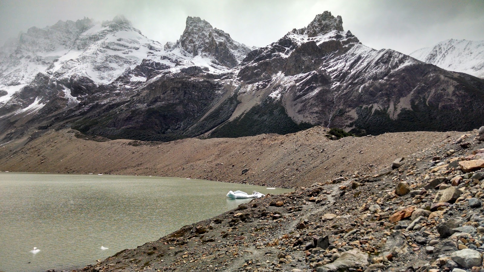
Terminal moraine that dams up Laguna Torre, El Chaltén, Patagonia.

Wednesday, January 14, 2015

El Chaltén, Patagonia


El Chaltén is a dedicated hiking/climbing town. There are something like 30 hostels in town (and a couple of fancier hotels). We stayed at Kospi Hostel, right in the center of this photograph. There are several trails right outside of town that head up into the mountains.

El Chaltén, Patagonia

Río de las Vueltas, El Chaltén, Patagonia


Tuesday, January 13, 2015

Going to Patagonia

We had already planned to visit our daughters in Buenos Aires for Christmas. But when your daughter sends you an email to ask if you want to hiking in Patagonia for a week, you say yes.

I flew to  Buenos Aires, where I met Libby and Annie and took a quick afternoon tour to change some money and visit the Google office for a snack. Later, we had a great asado (meat fest) with Libby's host family.

The next morning, we hopped on another plane for the three-hour flight to El Calafate, in Santa Cruz province.

Lago Argentino, El Calafate, Santa Cruz, Argentina.


Aerolíneas Argentinas had the nicest plane I've ever flown on: clean, bright, with leather seats. They also serve you little ham and cheese sandwiches with the crusts cut off.

Then, a three-hour bus ride up Route 40 (Argentina's loneliest highway, though it's mostly paved now and less lonely than it used to be, but still pretty windy) to El Chaltén, a town that exists as a basecamp for trekkers and climbers around the Patagonian icefields.

View from Argentina Route 40. Reminds me of U.S. Route 50 in Utah and Nevada.